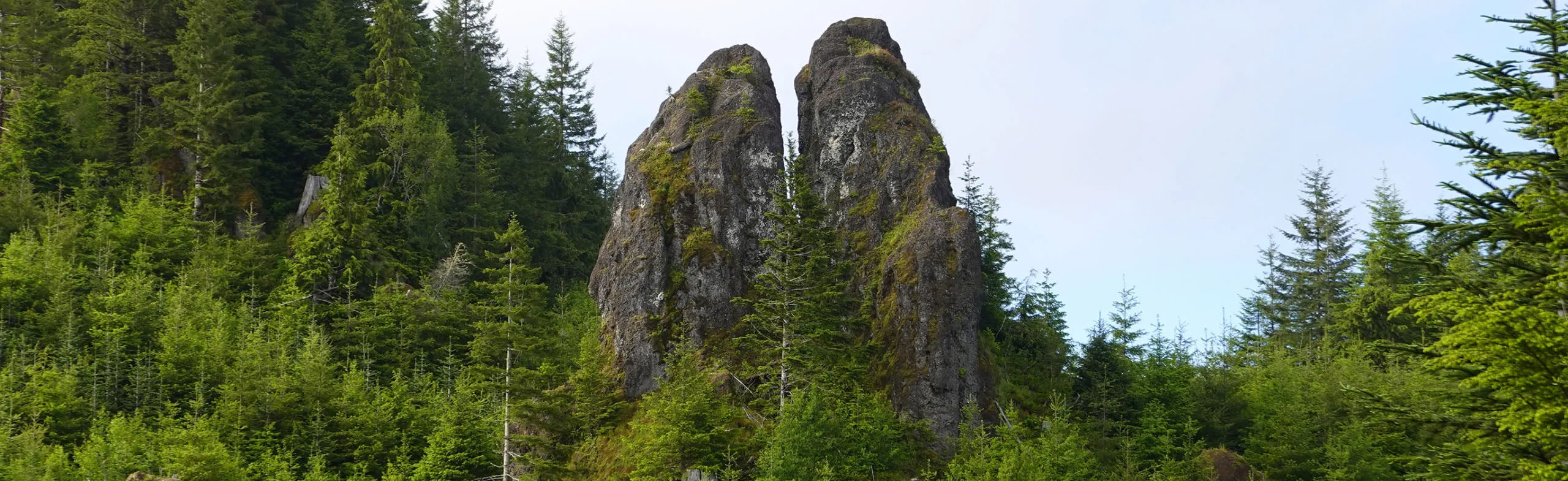
The locally famous Chocolate Ears Pinnacle is located near Wickiup Mtn in the northern Oregon Coast Range (approximately a dozen miles SE of Astoria).
Route Name: Bitter Sweet
First ascent: 6-23-22 Helser and Olson
Rating: 5.7, with 5 bolts total, height 50'.
Gear: helmet recommended, long sling draws, and/or quickdraws, one rope is sufficient.
Sport route (crux is first move off the ground), fixed with 3/8" bolts. Some minor loose crumbly rock, but most of the formation has a plethora of knobs, most of which are fairly solid for gripping and stepping on. The standard route is on the south side (the shorter aspect). From the edge of the forest, you will scramble up the low angle 3rd class loose rock slope to a flat landing stance. Belay where it becomes vertical at a nice wide comfy stance (the belayer will smile and eat all your food while you climb the pinnacle). The pinnacle is taller on its north aspect (about 100' tall) versus the shorter sunnier south aspect (about 55' tall).
Pitch 1 (lead climber): Move right a few feet to the deep slot notch that separates the two pillars; stem wide off both sides of the notch, clip the first bolt high on your left, then do a crux move going up left onto the vertical face. The difficulty eases immediately to sloped foot edges on a ramp landing at a small stance. Then continue up the lower angled slabby face aiming for the high right side (which overlooks the deep slot) stopping briefly a tiny stance, clip the last bolt, then make a final move up onto the sloped summit tip. Bolt belay station. Rappel 50' back down to the flat landing where your belayer is at.
This is private timberland (Lewis & Clark Timberland), so you must attain a free pass to access the land (available online at their website). If their gate is closed then you will not be able to drive to the site (note: their gate is on a different road that is further west on Hwy 202).
For our approach we opted for the 'always' open ODF roads, and parked on ODF land (at the high ODF gate) and walked the easy one mile loop around to the pinnacle. The difficult part of the entire approach is the last 200' of off-trail cross-country travel from the road to the pinnacle, all in the most dense pucker brush, festive mess you will ever encounter, so thick even the elk can't get through it, so enjoy getting on your hands and knees to crawl, grovel, jungle thrash, with stuff poking at your face, but suddenly after all that ... kaboom, you're there, and now you can get on with doing an ascent on the prize.
Reasonable minor climbable short pinnacles like this one are quite rare in the northern Oregon Coast Range. Often the rock is of shockingly poor quality (in the Coast Range), but this particular pinnacle is surprisingly a little bit better than most other rock formations in the coastal hills, partly due to its knobby character (most of the knobs are fairly solid), the conglomerate rocky type, and partly due to how the conglomerate formation was originally congealed (by heat and pressure).
K.H. website with more photos and info: Karl's Blog
Drive northwest of Portland on U.S.26, then north on Hwy 103, then northwest on Hwy 202 (through Jewel) on Nehalem Hwy. Turn off the paved road, and drive northeast onto graveled Simmons Ridge Road, and go uphill (this is on ODF roads / land). When Simmons road splits, stay on California Barrel Road and go all the way to the ODF high gate. Park there and begin your hike on the nice well-maintained flat gravel road (on the private timber company land) as it loops around to the pinnacle (about .9 mile one way).
Season: Best to climb it during a dry weather spell (should be dry weather at least one day prior). Ideal season if from May - October.
UTM 10t 452648 5103333
Lat-Lon 46.081934 -123.612433
The GPS UTM coordinates listed above are based using on Google-Earth only (the GPS locale may vary slightly in other mapping software).
If you are using Goo-maps or Bing-maps to see the mapped coordinates location, use a free online "UTM to Lat-Lon conversion tool" to get the Lat-Lon coordinates.
ODF access road: UTM 10t 452244 5102864 (at upper ODF gate) - if you utilize the ODF roads to their high gate. The benefit of the ODF roads...these roads are always open to public access (unless there are fire restrictions).
L&C access road: If you plan to access via the private timberland road, drive briefly further west on Hwy 202, then northeast/east on Lillenas Road to access their gate (or via Nordlund McCoy Lane?). If the gate is locked, you will have a 3 mile walk via this direction. See Lewis & Clark Timberland website for the access rules.


