Start over
Broughton Bluff
| Crag Name | Location | Orientation | Road Type | Trail Approach | Skill Level | Crag Height | Rock Type | Site Elevation | ||
|---|---|---|---|---|---|---|---|---|---|---|
| Summary | Broughton Bluff | Urban crag just east of Troutdale (east Portland metro) | West-Southwest [WSW] facing plus one north facing aspect. PM sunshine shaded by trees. | Paved road access to public parking lot | 200' elevation gain on well-graded path. About 5 minutes hiking approach (200' uphill gain). | All levels (basic, intermediate, advanced). Its vertical aspect is not the most ideal crag for pure beginning climbers. | Crag height ranges from 70'-200' tall, generally vertical, with numerous blocky ledges on some aspects (i.e. Hanging Gardens Wall). | Basalt rock with a smooth rock surface texture. May be mossy or dirty on lesser climbed walls. | Low elevation site near Sandy River (43' elevation at parking lot, and 250' at crag). | |
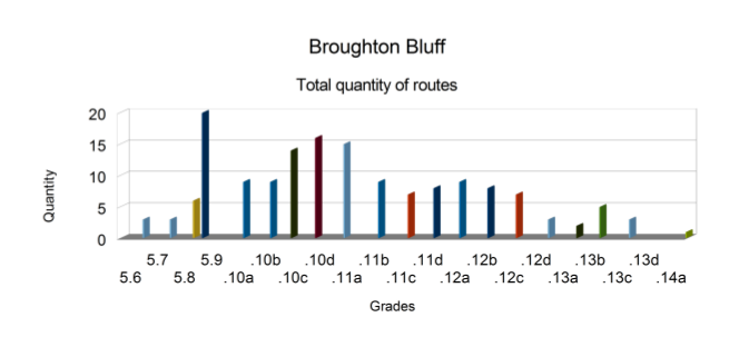
| Details | May through October (6-months) is best (plus some viable days during the winter). Crag is accessible year-round and climbable in winter if several dry days occur in a row. Some aspects (i.e. Bat Wall) are steep enough to be fairly dry even in the winter months. | Sport, Trad, QD+gear mixed, top-rope, and some nailing. Lower grades tend to be traditional gear leads. Many sport routes are available from 5.10+ to 5.12+. | Many single pitch leads (40'-100'), and some brief multi-pitch leads on the taller sections of cliff. | A single rack of gear (cams and stoppers to 3"-4") for trad leads. Quick-draws are sufficient for fully bolted sport leads. | Over 150+ routes (plus some additional unlisted or seldom climbed routes). Lowest rating: 5.6. Highest rating: 5.13. The greatest selection of grades range from 5.9 to 5.12- (and 5.9 has 20 routes). |  |
Most common routes are well established as free climbs. Some routes are seldom climbed and may be brushy/mossy. A few PG/R/X routes exist. Factors involve non-familiarity with slick basalt climbing. Technique is difficult to learn on smooth surfaced basalt. Use caution when accessing some of the belay stations if setting up a top-rope session. | Mosquitoes in spring and summer season (usually in late evening), wasps are active in late season on certain walls, and poison oak is common just off-trail. Strong east wind in winter may limit user interest. | Oregon state park with a public rest facility, a boat ramp, and public parking (no fee). The parking lot entrance gate gets locked at dusk each day. Hike out by sunset to avoid risk of being locked inside gate. | PRC Broughton's section |
Rocky Butte Quarry
| Crag Name | Location | Orientation | Road Type | Trail Approach | Skill Level | Crag Height | Rock Type | Site Elevation | ||
|---|---|---|---|---|---|---|---|---|---|---|
| Summary | Rocky Butte Quarry | Urban inner city location in NE Portland. Year-round access and parking available along the shoulder of the street. | North-facing (N) deciduous tree shaded environment with minimal filtered sunlight. In winter months moisture may seep down some of the bluff (i.e. Video Bluff) bringing a slight surface dust film with it, but in summer with use it quickly fades. Some aspects are steep enough to remain fairly dry much of the year. | Paved road access. Convenient parking at top of bluff. | Basic user paths exist along the cliff top offering a 1-3 minutes approach depending on your goal (cliff-top or cliff-base). But caution must be used when near the cliff edge, or while descending the steep paths to access the cliff base. Some base sections have garbage debris. | Popular for beginner, intermediate, and expert levels of climbing. | Cliff height ranges from 40' to 70', is often vertical with numerous edges or ledges on some routes. | Basalt rock with numerous edges and ledges. May be mossy or dirty on lesser climbed sections. Water seepage tends to add surface grime on the slabby sections. | Low elevation site (350' elevation at top of wall). | |
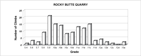
| Details | May through October is best (when the rock is driest). Heavy rain showers may hinder climb-ability until the rock surface dries. Winter rainy months tend to keep the crag damp and virtually unusable. | Both sport and traditional leads, and mixed gear/bolt leads. All are short single pitch leads, but most climbs are used as top-rope sessions these days. | Common length of routes range from 40' to 70'. Only in a few spots does the cliff exceed this height. | Single rack of gear and/or quick-draws depending on your goal. Slings and locking carabiners to set up top-rope anchors from various trees (wherever no top anchor exists). | About 135+ climbing routes. More routes do exist but are generally not climbed (some routes are located below the residential homes). Lowest rating: 5.4, Highest rating: 5.13a. The greatest selection of grades range from 5.8 to 5.11c (and 5.9 has 20 routes). |  |
Use caution when approaching the upper edge of the cliff to set up top-rope anchors. The soil can be slick, and some fixed top-anchors are difficult to reach. Some old fixed gear may be missing. | Freeway noise (mainly at east part of crag), mosquitoes in spring (or late evenings). Some blackberry bushes, other brush, and slick paths along base of the crag are a detraction. Most climbers just set up TR's from above. The crag is wrapped in a thick forest canopy covered environment. | City of Portland property and no specific regs. | PRC Rocky Butte Quarry section |
Carver Bridge Cliff
| Crag Name | Location | Orientation | Road Type | Trail Approach | Skill Level | Crag Height | Rock Type | Site Elevation | ||
|---|---|---|---|---|---|---|---|---|---|---|
| Summary | Carver Bridge Cliff | Urban crag near Clackamas, Oregon. Year-round access, with private owner stated limitations (must sign liability release waiver). | North facing tree shaded environment. | Paved road access, and a gravel parking spot. | Narrow user made foot paths. It is a 1 minute walk to reach the crag. | Beginner, intermediate, and advanced. | Highest section is about 100' tall, but only a few routes go to the top (most are 40-50' leads). Cliff is vertical with (sloped) edges or ledges on some routes. A small slab alcove exists. | Andesitic rock with crimps and natural pockets. Some routes have regrown with moss. | It's 190' elevation at the parking spot, and 240' at the crag base. | |
| Details | From May through October is best. Winter rainy months often keep the crag damp and unclimbable. A series of dry days in winter may dry out some of the routes. | Primarily sport leads (and a few trad leads). Short single pitch (40'-60') leads are common. | Single pitch leads (40' to 120'). Some mid-point belays allow a second short lead on certain routes. | Many routes are QD leads (for fully bolted routes). A gear rack (cams and stoppers to 3" if doing trade leads). Some routes are mixed gear/bolt leads so mandatory gear of some kind is needed. | About 54 routes (more routes do exist but those are well-overgrown with moss and plants). Lowest rating: 5.4, Highest rating: 5.13a. The greatest selection of grades range from 5.7 to 5.12- (and strong emphasis on 5.9 and 5.10a with 7 of each rating). |  |
Most routes are well protected bolt lines. Some routes are techy trad or mixed gear leads. | Mosquitoes in spring season (or late evenings). Moss regrowth on many longer routes limits leading options to just the lower popular climbs today. Poison oak exists along certain parts of the cliff top. | Private property. Visitors must sign liability release waver prior to climbing here, and obey all rules. | PRC Carver Cliff section |
Madrone Wall
| Crag Name | Location | Orientation | Road Type | Trail Approach | Skill Level | Crag Height | Rock Type | Site Elevation | ||
|---|---|---|---|---|---|---|---|---|---|---|
| Summary | Madrone Wall | Rural area, just outside of city limits, on a major highway corridor. Residential development in the area is notable. The crag site is about 10-minutes drive from Clackamas, Oregon. | Southwest facing crag, and full afternoon sunshine (at Shining Wall). Partially tree shaded environment for the majority of the wall. | Paved road access on highway, then short side road to parking area. County maintained property. | Established hiker trails to the crag base. | Beginner, intermediate, to expert. Good opportunities for intermediate level climbers because of the plethora of lower level grades to climb (5.8 to 5.9). | Cliff height is 90-100' tall max (most routes are much shorter). Cliff is mostly vertical with some slightly overhung sections. Many routes have a plethora of edges or ledges. | Basaltic rock with crimps, edges and ledges. Good quality routes on quality rock. | Low elevation crag 155' elevation at road, and 330' at crag. | |
| Details | Year-round climbing, weather permitting (except if closed for falcon nesting). One of Portland's best crags. | Sport leads, trad leads, and mixed gear/bolt leads. | Leads range from 40' to 80' in length with occasional mid-point belay anchors on certain routes. | A set of quick-draws and a single set of trad gear (stoppers and cams) will suffice. | About 120 routes; the lowest is 5.4, and the highest is 5.12c (5.9 has 19 routes, 5.10a has 18 routes). The greatest concentration of routes range from 5.9 to 5.11+. |  |
A few leads are technical gear leads involving PG/R/X considerations. | Poison oak exists along the trail and at the crag, but not at the well-defined climbing spots. | Clackamas County owned and maintained property. Daily access parking fee. | PRC Madrone section |